Publications
Get a glimpse of my academic adventures – from groundbreaking publications to eye-catching posters 😆
2026
-
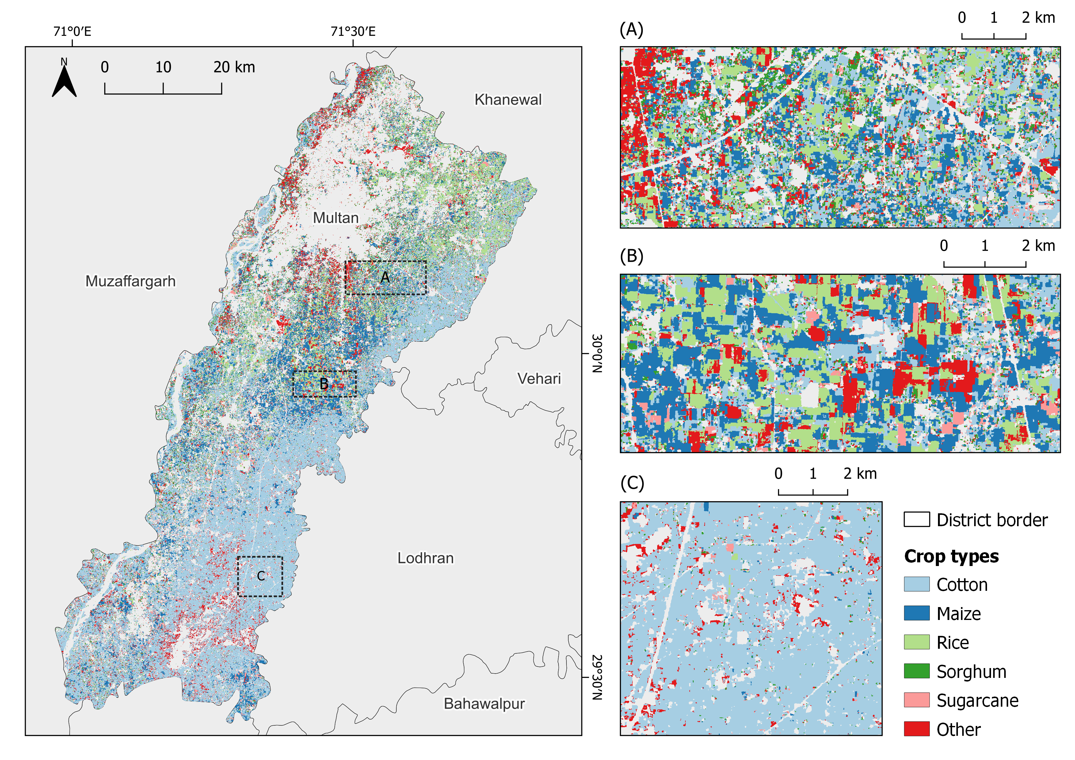 Crop type classification in smallholder agriculture of Central and South Asia using Sentinel-1/2 data fusionChristoph Raab, Viet Duc Nguyen, Brian Barrett, Aksana Zakirova, Mehwish Zuberi, Henryk Alff, and Michael SpiesRemote Sensing Applications: Society and Environment, 2026
Accurate crop monitoring in smallholder-dominated regions is challenging due to fragmented fields, high crop diversity, and often limited ground truth data. This study presents a systematic and transferable framework for crop-type classification in smallholder systems by jointly evaluating multi-sensor data fusion, temporal feature aggregation, feature selection, and model applicability. This study evaluates crop-type classification accuracy across smallholder agricultural landscapes in Central and South Asia (Kazakhstan, Tajikistan, Pakistan), leveraging Sentinel-1 radar and Sentinel-2 optical data separately and combined. Employing Random Forest models, we systematically compare temporal aggregation approaches (monthly, bi-monthly, quarterly) and evaluate the impact of feature selection on model performance. Across all study regions, combined Sentinel-1 and Sentinel-2 data achieved overall classification accuracies of approximately 80–96%, with substantial performance gains relative to single-sensor models, particularly in regions where individual sensors showed limited discrimination capability. Depending on region and sensor, accuracy improvements ranged from a few percentage points to more pronounced gains, reflecting strong benefits of data fusion in heterogeneous smallholder systems. Finer temporal aggregation schemes, including monthly aggregation, yielded additional accuracy gains of approximately 1–3 percentage points compared to coarser aggregations, while feature selection further improved model performance by roughly 2–5 percentage points. Sentinel-1 proved particularly effective for structurally distinct crops such as cotton, while Sentinel-2 substantially improved classification of more diverse crop classes. Application of the Area of Applicability concept enabled spatially explicit identification of well-supported and extrapolated predictions, providing a quantitative basis for uncertainty assessment and future sampling strategies. Together, these results demonstrate the value of an integrated and transferable methodological framework for robust crop-type classification in smallholder agricultural systems using freely available Sentinel data.
2024
-
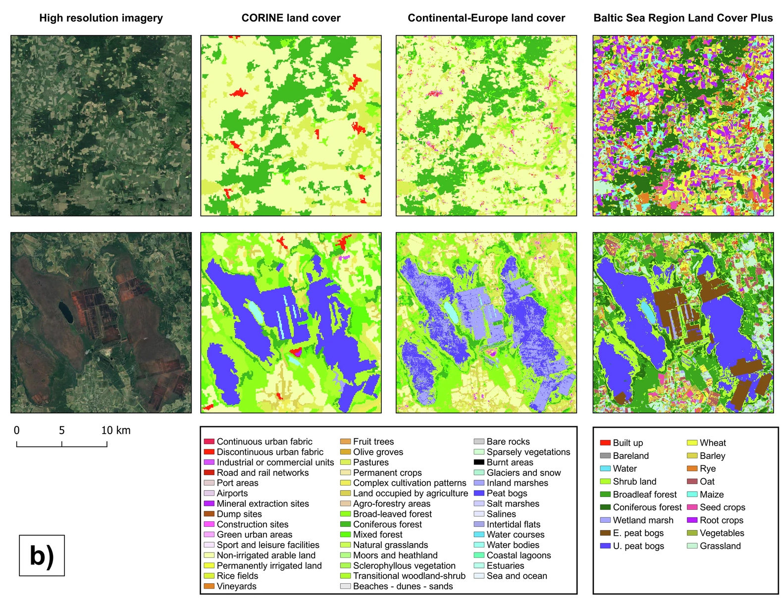 An annual land cover dataset for the Baltic Sea Region with crop types and peat bogs at 30 m from 2000 to 2022Vu-Dong Pham, Farina Waard, Fabian Thiel, Bernd Bobertz, Christina Hellmann, Duc-Viet Nguyen, Felix Beer, M Arasumani, Marcel Schwieder, Jörg Hartleib, and othersScientific Data, 2024
We present detailed annual land cover maps for the Baltic Sea region, spanning more than two decades (2000-2022). The maps provide information on eighteen land cover (LC) classes, including eight general LC types, eight major crop types and grassland, and two peat bog-related classes. Our maps represent the first homogenized annual dataset for the region and address gaps in current land use and land cover products, such as a lack of detail on crop sequences and peat bog exploitation. To create the maps, we used annual multi-temporal remote sensing data combined with a data encoding structure and deep learning classification. We obtained the training data from publicly available open datasets. The maps were validated using independent field survey data from the Land Use/Cover Area Frame Survey (LUCAS) and expert annotations from high-resolution imagery. The quantitative and qualitative results of the maps provide a reliable data source for monitoring agricultural transformations, peat bog exploitation, and restoration activities in the Baltic Sea region and its surrounding countries.